1
2
3
4
5
6
7
8
9
10
11
12
13
14
15
16
17
18
19
20
21
22
23
24
25
26
27
28
29
30
31
32
33
34
35
36
37
38
39
40
41
42
43
44
45
46
47
48
49
50
51
52
53
54
55
56
57
58
59
60
61
62
63
64
65
66
67
68
69
70
71
72
73
74
75
76
77
78
79
80
81
82
83
84
85
86
87
88
89
90
91
92
93
94
95
96
97
98
99
100
101
102
103
104
105
106
107
108
109
110
111
112
113
114
115
116
117
118
119
120
121
122
123
124
125
126
127
128
129
130
131
132
133
134
135
136
137
138
139
140
141
142
143
144
145
146
147
148
149
150
151
152
153
154
155
156
157
158
159
160
161
162
163
164
165
166
167
168
169
170
171
172
173
174
175
176
177
178
179
180
181
182
183
184
185
186
187
188
189
190
191
192
193
194
195
196
197
198
199
200
201
202
203
204
205
206
207
208
209
210
211
212
213
214
215
216
217
218
219
220
221
222
223
224
225
226
227
228
229
230
231
232
233
234
235
236
237
238
239
240
241
242
243
244
245
246
247
248
249
250
251
252
253
254
255
256
257
258
259
260
261
262
263
264
265
266
267
268
269
270
271
272
273
274
275
276
277
278
279
280
281
282
283
284
285
286
287
288
289
290
291
292
293
294
295
296
297
298
299
300
301
302
303
304
305
306
307
308
309
310
311
312
313
314
315
316
| import json
import math
import os
import shutil
from osgeo import gdal, osr
import gdal2tiles
from concurrent.futures import ThreadPoolExecutor
import threading
import sys
import uuid
def init_params():
"""
初始化参数
"""
temp_input_list = []
input_list = []
try:
with open('arg.json', 'r') as file:
json_data = json.load(file)
o_type = json_data["type"]
path_list = json_data["path_list"]
path_route = json_data["path_route"]
output_route = json_data["output_route"]
max_level = json_data["max_level"]
if o_type == "file":
if len(path_list) == 0:
exit_app("path数据为空,切片结束")
temp_input_list = path_list
elif o_type == "folder":
if os.path.exists(path_route) is False:
exit_app("路径不存在,请检查路径")
for root, dirs, files in os.walk(path_route):
for file in files:
file_extension = os.path.splitext(os.path.basename(file))[1]
if file_extension in [".tiff", ".tif", ".TIF", ".TIFF"]:
temp_input_list.append(os.path.join(root, file))
else:
exit_app("type参数只支持:folder和file")
if (max_level != "auto" and not isinstance(max_level, int)) or (isinstance(max_level, int) and max_level < 0):
exit_app(f"max_level参数支支持:auto和int类型")
for f in temp_input_list:
pt = check_wgs84_coordinate_system(f)
if pt != "":
input_list.append(pt)
else:
with open(os.path.join(log_path, 'error.txt'), 'a') as file:
file.write(f"[切片数据]:{f} [error] 数据无坐标切片失败! \n")
total_img = len(temp_input_list)
return input_list, output_route, total_img, max_level
except Exception as e:
exit_app(f"参数初始化错误!强制退出!Error:{e}")
def check_wgs84_coordinate_system(image_path):
temp_path = os.path.join("temp", "tif")
if not os.path.exists(temp_path):
os.makedirs(temp_path)
dataset = gdal.Open(image_path, gdal.GA_ReadOnly)
if dataset is None:
print("影像打开失败!")
return ""
projection = dataset.GetProjection()
geo_transform = dataset.GetGeoTransform()
if projection is not None and geo_transform is not None:
if projection == '':
return ''
else:
return ''
srs = osr.SpatialReference()
srs.ImportFromWkt(projection)
if srs.GetAuthorityCode(None) != '4326' or srs.GetAttrValue("GEOGCS") != "WGS 84":
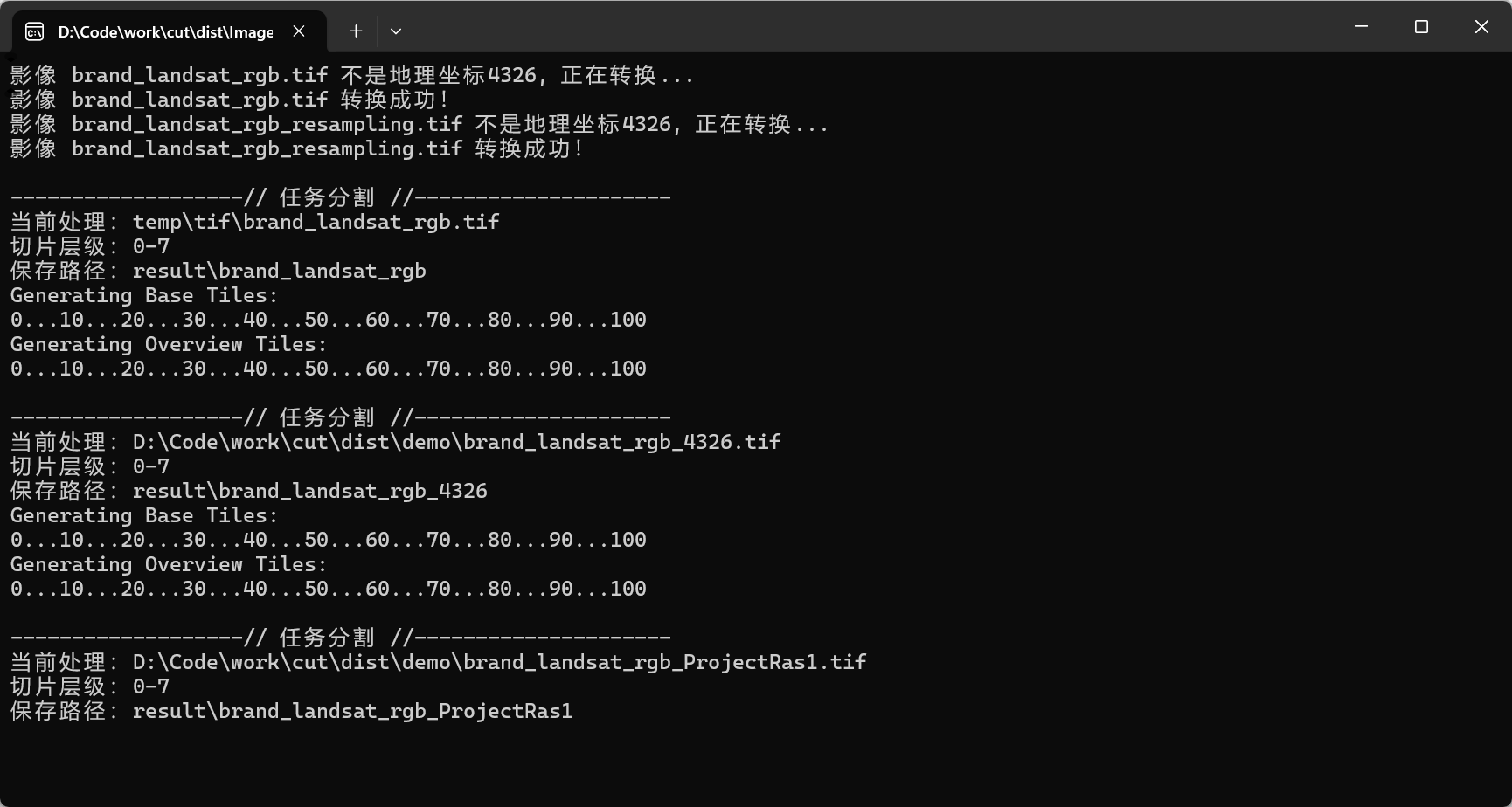
print(f"影像 {os.path.basename(image_path)} 不是地理坐标wgs84(EPSG:4326), 正在转换...")
new_file = os.path.join(temp_path, os.path.basename(image_path))
gdal.Warp(new_file, dataset, dstSRS="EPSG:4326")
print(f"影像 {os.path.basename(image_path)} 转换成功!")
return new_file
else:
return image_path
def create_result_dir():
"""
创建日志目录文件
:return:
"""
try:
random_uuid = str(uuid.uuid4())
log_path_folder = os.path.join('log', random_uuid)
if not os.path.exists(log_path_folder):
os.makedirs(log_path_folder)
return log_path_folder
else:
print("路径重复!")
create_result_dir()
except OSError as e:
print(f"路径创建出错: {e}")
except RecursionError:
print(f"")
exit_app("程序循环异常!强制退出!")
def delete_folder_contents(path):
"""
清空目录
:param path: 路径
"""
for item in os.listdir(path):
item_path = os.path.join(path, item)
if os.path.isfile(item_path):
os.remove(item_path)
elif os.path.isdir(item_path):
shutil.rmtree(item_path)
def check_and_create_path(target_path, source_path):
"""
保存路径检查,清空目录和创建目录(根据源文件名创建切片文件夹)
:param target_path: 保存的基础路径
:param source_path: 源文件路径
"""
filename = os.path.splitext(os.path.basename(source_path))[0]
path = os.path.join(target_path, filename)
if not os.path.exists(path):
try:
os.makedirs(path)
except OSError as e:
print(f"Error: {e}")
else:
delete_folder_contents(path)
return path
def computed_max_level(ds, tile_size=256):
"""
计算最大切片范围(简单推算)
:param tile_size:
:param ds: gdal打开的数据
:return: 级别
"""
if max_zoom != "auto" and isinstance(max_zoom, int):
return max_zoom
width = ds.RasterXSize
height = ds.RasterYSize
geo_transform = ds.GetGeoTransform()
pixel_size_x = geo_transform[1]
pixel_size_y = geo_transform[5]
resolution = math.sqrt(pixel_size_x * pixel_size_x + pixel_size_y * pixel_size_y)
maxLevel = math.ceil(math.log2(max(width, height) / resolution))
for zoom_level in range(0, maxLevel + 1):
tiles_x = (width + tile_size * 2 ** zoom_level - 1) // (tile_size * 2 ** zoom_level)
tiles_y = (height + tile_size * 2 ** zoom_level - 1) // (tile_size * 2 ** zoom_level)
if tiles_x == 1 or tiles_y == 1:
maxLevel = zoom_level
if maxLevel < 7:
maxLevel = 7
break
return maxLevel
def get_bbox(ds):
"""
获取影像的地理范围
:param ds: gdal打开的数据
:return: 地理范围 tuple元组 (minx, miny, maxx, maxy)
"""
geo_transform = ds.GetGeoTransform()
minx = geo_transform[0]
maxy = geo_transform[3]
maxx = minx + geo_transform[1] * ds.RasterXSize
miny = maxy + geo_transform[5] * ds.RasterYSize
return minx, miny, maxx, maxy
def clear_files(path):
"""
清理切片生成的无关文件
:param path: 切片保存路径
:return:
"""
print("正在整理切片生成的文件,请等待...")
for root, dirs, files in os.walk(path):
for file in files:
filename, file_extension = os.path.splitext(file)
if file_extension != ".png" and filename != "tilemapresource":
file_path = os.path.join(root, file)
os.remove(file_path)
print("数据整理完毕!")
def start_cut_img(img_path):
"""
切片启动函数
:param img_path: 单张tif路径
:return:
"""
save_path = check_and_create_path(save_base_path, img_path)
img = gdal.Open(img_path)
maxZoom = computed_max_level(img)
bbox = get_bbox(img)
options = {
"zoom": (0, maxZoom),
"profile": "geodetic",
"s_srs": "EPSG:4326",
"tile_size": 256,
"tmscompatible": True,
"resampling": "near",
'np_processes': 3,
'kml': False,
'srcnodata': None,
'config': ['SRC_METHOD=NO_GEOTRANSFORM'],
"bbox": bbox,
}
print()
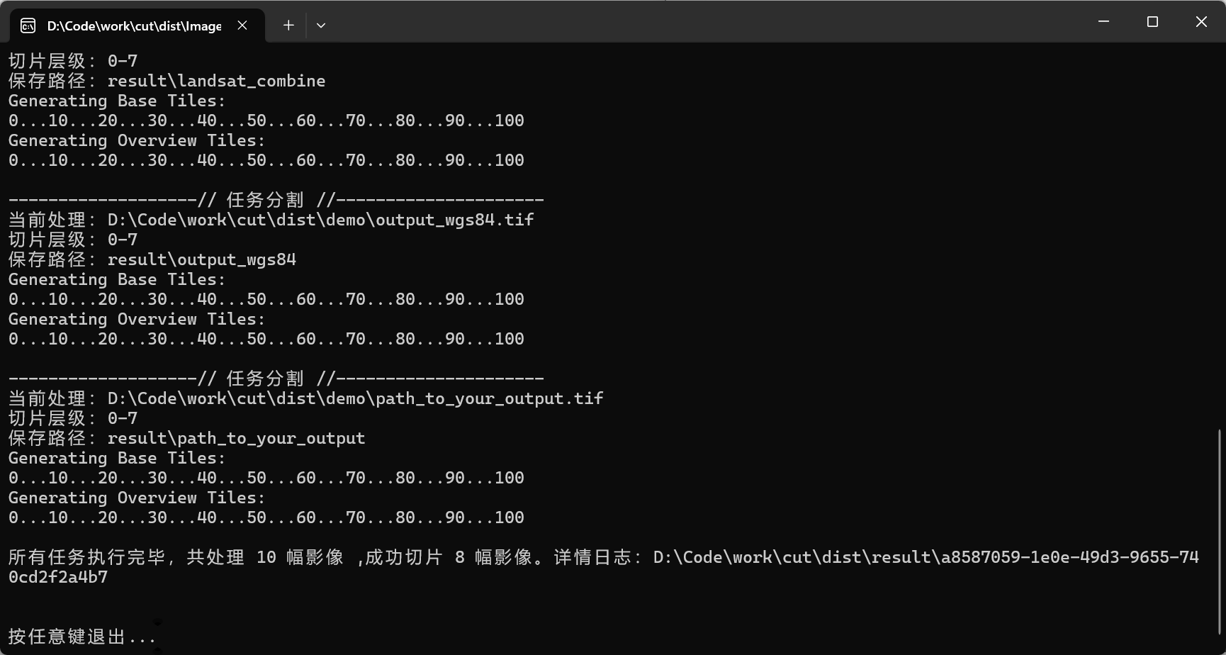
print('-------------------// 任务开始 //---------------------')
print(f'当前处理:{img_path}')
print(f'切片层级:0-{maxZoom}')
print(f'保存路径:{save_path}')
gdal2tiles.generate_tiles(img_path, save_path, **options)
clear_files(save_path)
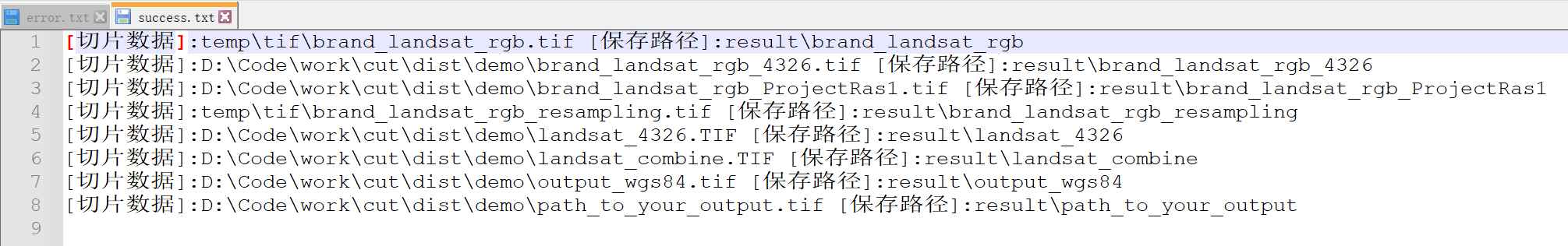
with open(os.path.join(log_path, 'success.txt'), 'a') as file:
file.write(f"[切片数据]:{img_path} [保存路径]:{save_path} \n")
print('-------------------// 任务结束 //---------------------')
def generate_tiles_th(input_image):
"""
线程函数管理
:param input_image:
:return:
"""
with lock:
start_cut_img(input_image)
def exit_app(msg="", code=1):
"""
退出程序
:param code: 0 代表正常退出,其它值代码异常退出
:param msg: 退出前的提示
:return:q
"""
print()
print(msg)
print("按下任意键然后回车退出:")
print("正在清理临时目录文件夹...")
delete_folder_contents("temp")
print("清理完毕!")
sys.exit(code)
if __name__ == '__main__':
lock = threading.Lock()
max_workers = 3
log_path = create_result_dir()
input_path_list, save_base_path, total, max_zoom = init_params()
with ThreadPoolExecutor(max_workers=max_workers) as executor:
executor.map(generate_tiles_th, input_path_list)
print()
print(f"所有任务执行完毕,共处理 {total} 幅影像 ,成功切片 {len(input_path_list)} 幅影像。详情日志:{os.path.join(os.getcwd(), log_path)}")
exit_app("", 0)
|


 微信
微信 支付宝
支付宝